At its April meeting, the Louisiana Wildlife and Fisheries Commission undesignated a portion of the Public Oyster Seed Grounds east of the Mississippi River. This action will not occur until the first lottery phase of the oyster moratorium lifting process commences. The Louisiana Wildlife and Fisheries Commission will continue considering the oyster moratorium lifting process in the coming months.
Lifting the long-standing oyster lease moratorium and turning some public oyster grounds into leasable areas is part of an ongoing effort by the state to assist the oyster industry in adapting to changing coastal conditions.
“The state is giving up these public oyster seed grounds to help provide the oyster industry with an opportunity to move to more productive areas – to adapt to both natural and man-made changes in coastal Louisiana, including erosion and shifting salinity levels,” explained LDWF Secretary Jack Montoucet. “With over 1.7 million acres of public oyster grounds, the state does not have the resources to develop oyster reefs everywhere. One of the best things we can do is make this area available for private investment through our oyster leasing process.”
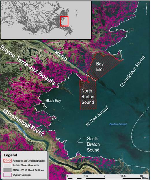
Approximately 40,248 acres of the seed grounds in Bay Eloi and northern Breton Sound will no longer be designated as a seed ground upon commencement of the first lottery phase of the oyster moratorium lifting process (also described as Phase Four of Section 2 of Act 595 of the 2016 Regular Session of the Legislature). This acreage only consists of 4 percent of the Public Oyster Seed Ground area east of the Mississippi River.
The below described areas will no longer be designated as a seed ground and will be available for oyster leasing upon commencement of the first lottery phase of the oyster moratorium lifting process.
a. North Breton Sound
i. 89 degrees 24 minutes 00.000 seconds W
29 degrees 41 minutes 00.468 seconds N;
ii. 89 degrees 24 minutes 00.000 seconds W
29 degrees 34 minutes 30.000 seconds N;
iii. 89 degrees 27 minutes 56.000 seconds W
29 degrees 34 minutes 30.000 seconds N;
iv. 89 degrees 27 minutes 56.000 seconds W
29 degrees 41 minutes 12.400 seconds N;
v. following the current public oyster seed ground boundary line and shorelines back to point of beginning.
b. Bay Eloi
i. 89 degrees 17 minutes 12.190 seconds W
29 degrees 45 minutes 49.160 seconds N;
ii. 89 degrees 23 minutes 46.500 seconds W
29 degrees 41 minutes 09.948 seconds N;
iii. following the current public oyster seed ground boundary line and shorelines back to point of beginning.
See below for a map depicting these areas.
The Louisiana Department of Wildlife and Fisheries is charged with managing and protecting Louisiana’s abundant natural resources. For more information, visit us atwww.wlf.la.gov. To receive email alerts, signup at http://www.wlf.la.gov/signup.