
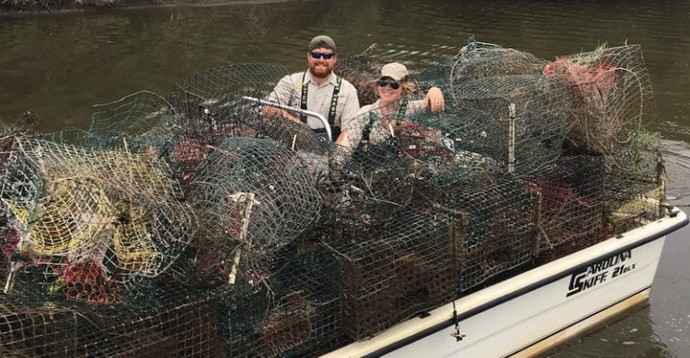
At today’s meeting, the Louisiana Wildlife and Fisheries Commission adopted a Notice of Intent (NOI) allowing the removal of derelict crab traps from seven different areas along Louisiana’s coast in 2018.
Since 2004, the Louisiana Department of Wildlife and Fisheries, together with individual volunteers and organizations, has successfully removed and disposed of over 33,000 abandoned and derelict crabs. The removal of these crab traps is especially important to boating safety and crab harvesting efforts. Last year, LDWF, Lake Pontchartrain Basin Foundation members, volunteers, CCA and members of the recreational fishing community assisted in retrieving more than 5,600 abandoned crab traps.
- The first closure will take place in the upper Barataria Basin and adjacent marshes, west of Port Sulphur, and will begin at 12 a.m. Thursday, February 1, 2018, through 11:59 p.m. Wednesday, February 14, 2018.
- The second closure will take place in Lake Pontchartrain, west of the Lake Pontchartrain Causeway, and will begin at 12 a.m. Thursday, February 1, 2018, through 11:59 p.m. February 10, 2018.
- The third closure will take place in Sabine Lake and will run concurrent with the Texas Parks and Wildlife Department closure of Sabine Lake. Both the Louisiana and Texas portions of Sabine Lake will be temporarily restricted for the use of crab traps to eliminate confusion during trap cleanup efforts. The Sabine Lake crab trap closure is scheduled to begin at 12 a.m. February 16, 2018, through 11:59 p.m. February 25, 2018.
- The fourth cleanup will be located in the Pontchartrain Basin, just north of the MRGO, including the southern portion of Lake Borgne and the area around Bayou La Loutre. This closure will begin at 12:00 a.m. February 16, 2018, through 11:59 p.m. March 3, 2018.
- The fifth closure area will be located in the Pontchartrain Basin, within the area from Delacroix to the MRGO, beginning at 12 a.m. March 4, 2018, through 11:59 p.m. March 19, 2018.
- The sixth closure area will take place in the Terrebonne Basin, in an area from Dulac south beyond Cocodrie beginning at 12 a.m. March 16, 2018, through 11:59 pm March 29, 2018.
- The seventh closure area will be in the Vermilion-Teche Basin, in the West Cote Blanche Bar area beginning at 12 a.m. March 18, 2018, through 11:59 pm March 31, 2018.
Barataria Basin Crab Trap Removal
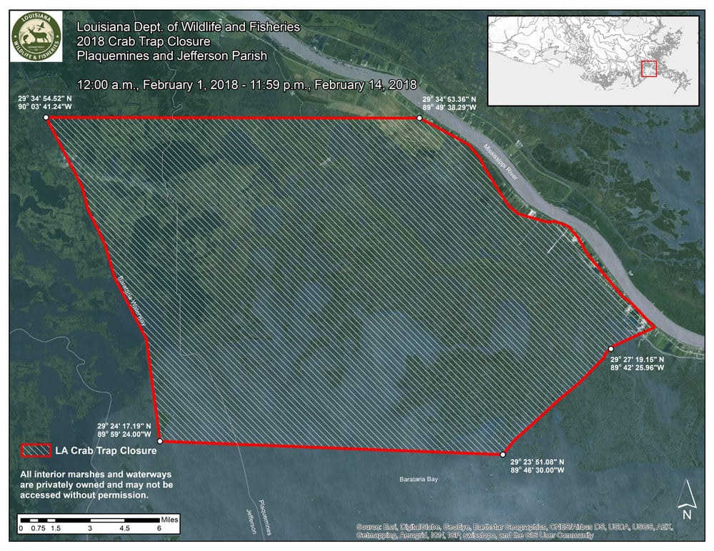
Click to enlarge
The use of crab traps shall be prohibited for a 14-day period from 12 a.m. February 1, 2018, through 11:59 p.m. February 14, 2018:
- From a point originating on the western boundary of the Barataria Waterway (Lat. 29° 34′ 54.52″ N., Long. 90° 3′ 41.24″ W.), then eastward to the intersection of Highway 23 and Reddick Lane (Lat. 29° 34′ 53.36″ N., Long. 89° 49′ 38.29″ W.), then southward on Highway 23 to the intersection of Caroline Avenue and Highway 23, then southwesterly to a point where Little Pass and the southern bank of the Freeport Sulphur Canal intersect (Lat. 29 o 27’ 19.15”N Long. 89 o 42’ 25.96” W.), then southwest to the point located at Lat. 29° 23′ 51.08″ N., Long. 89° 46′ 30.00″ W., then westward to a point located at Lat. 29° 24′ 17.19″ N., Long. 89° 59′ 24.00″ W., then northward following the Baratraia Waterway, then terminating at a point Lat. 29° 34′ 54.52″ N., Long. 90° 3′ 41.24″ W
West Lake Pontchartrain Crab Trap Removal
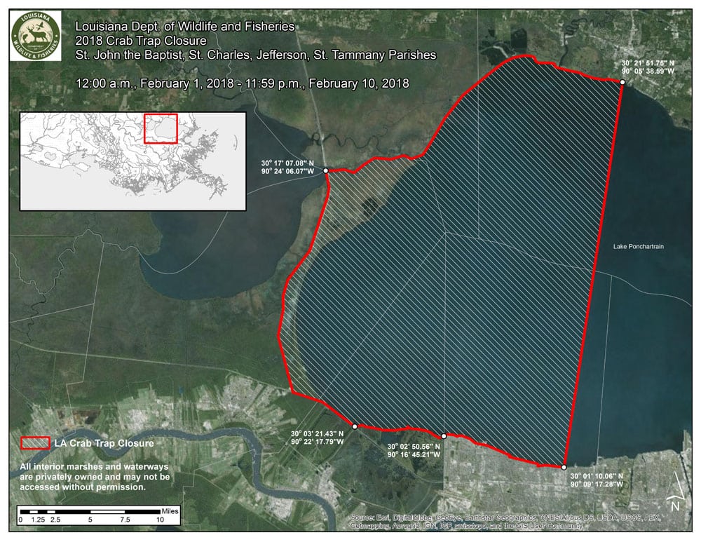
Click to enlarge
The use of crab traps shall be prohibited for a 10-day period from 12 a.m. February 1, 2018, through 11:59 p.m. February 10, 2018:
- From a point of origin where I-55 intersects Pass Manchac (Lat. 30 ° 17′ 7.08″ N., Long. 90 ° 24′ 6.07″ W.), then eastward where Pass Manchac exits at the northwest bank of Lake Pontchartrain, then northward following the bank of Lake Pontchartrain to the south bound lane of the Lake Pontchartrain Causeway (Lat. 30 ° 21′ 51.75″ N., Long. 90 ° 5′ 38.59″ W.), then southward to a point where the Lake Pontchartrain Causeway crosses the Lakefront Trail located (Lat. 30 ° 1′ 10.06″ N., Long. 90 ° 9′ 17.28″ W.), then westward following the Lakefront trail along the south bank of Lake Pontchartrain until it intersects the Duncan Canal (Lat. 30 ° 2′ 50.56″ N., Long. 90 ° 16′ 45.21″ W.), then westward past the Duncan Canal continuing to follow the south bank of Lake Pontchartrain to a point where I-10 passes over the southern bank of Lake Pontchartrain (Lat. 30 ° 3′ 21.43″ N., Long. 90 ° 22′ 17.79″ W.), then westward on I-10 to the intersection of I-55, then northward on I-55 and terminating at the location I-55 crossing over Pass Manchac (Lat. 30 ° 17′ 7.08″ N., Long. 90 ° 24′ 6.07″ W.)
Sabine Basin Crab Trap Removal
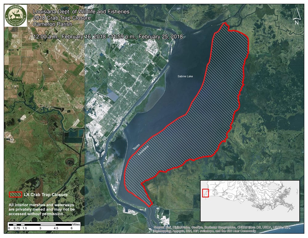
Click to enlarge
The use of crab traps shall be prohibited for a 10-day period from 12 a.m. February 16, 2018, through 11:59 p.m. February 25, 2018:
- From a point originating from the intersection of the southern side of LA Highway 82 and the eastern shore of Sabine Lake, then north along the eastern shoreline of Sabine Lake to its intersection with East Pass, then due north to Sabine Island, then west along the southern shoreline of Sabine Island to its westward most point, then due west to the Texas state line, then south along the Louisiana / Texas state line to its intersection with LA Highway 82, then east along the southern side of LA Highway 82 and terminating at its intersection with the eastern shore of Sabine Lake
Pontchartrain Basin Crab Trap Removal
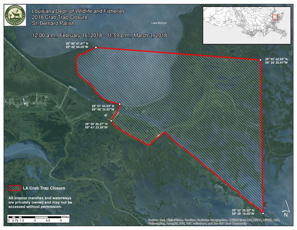
Click to enlarge
The use of crab traps shall be prohibited for a 16-day period from 12 a.m. February 16, 2018, through 11:59 p.m. March 3, 2018:
- From a point of origin located at the most northeastern corner of Proctor Point in Lake Borgne (Lat. 29 ° 56′ 47.47″ N., Long. 89 ° 42′ 54.25″ W.), then eastward to the most northwestern point in Lake Eugenie (Lat. 29 ° 55′ 42.99″ N., Long. 89 ° 26′ 32.41″ W.), then southward past Coon Nest Island to a point located on the western bank of the Mississippi River Gulf Outlet (MRGO) (Lat. 29 ° 42′ 29.25″ N., Long. 89 ° 26′ 16.56″ W.), then northwestward following the western bank of the MRGO to the intersection of Bayou La Loutre, then westward to the intersection of Bayou La Loutre and the Shell Beach Cut (Lat. 29 ° 50′ 28.27″ N., Long. 89 ° 41′ 23.38″ W.), then following the western bank of the Shell Beach Cut northward to its entry point at Lake Borgne (Lat. 29 ° 51′ 54.53″ N., Long. 89 ° 40′ 32.52″ W.), then westward following the southern bank of Lake Borgne as it makes its northern turn at Proctor Point and terminating at the northeastern corner of Proctor Point (Lat. 29 ° 56′ 47.47″ N., Long. 89 ° 42′ 54.25″ W.)
Pontchartrain Basin Crab Trap Removal
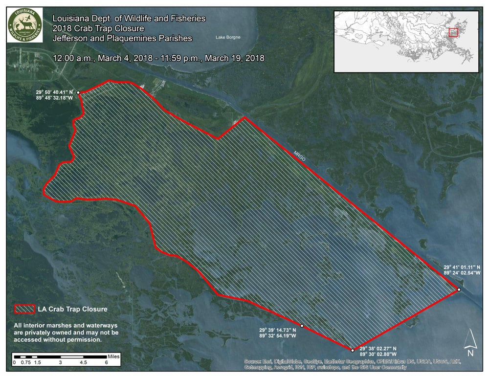
Click to enlarge
The use of crab traps shall be prohibited for a 16-day period from 12 a.m. March 4, 2018, through 11:59 p.m. March 19, 2018:
- From a point located where Bayou La Loutre crosses under Highway 300 (Lat. 29 ° 50′ 40.41″ N., Long. 89 ° 45′ 32.18″ W.), then south on Highway 300 to Sweetwater Marina in Delacroix, then south following the western bank of Bayou Terre aux Boeufs to its point of exit into Black Bay (Lat. 29 ° 39′ 14.73″ N., Long. 89 ° 32′ 54.19″ W.), then southeastward to a point located at the southern tip of Mozambique Point (Lat. 29 ° 38′ 2.27″ N., Long. 89 ° 30′ 2.80″ W.), then eastward to a point located on the western bank of the MRGO, across from Grace Point, (Lat. 29 ° 41′ 1.11″ N., Long. 89 ° 24′ 2.54″ W.), then northwestward following the western bank of the MRGO to the intersection of Bayou La Loutre, then westward following Bayou La Loutre and terminating where Bayou La Loutre intersects with Highway 300 (Lat. 29 ° 50′ 40.41″ N., Long. 89 ° 45′ 32.18″ W.)
Terrebonne Basin Crab Trap Removal
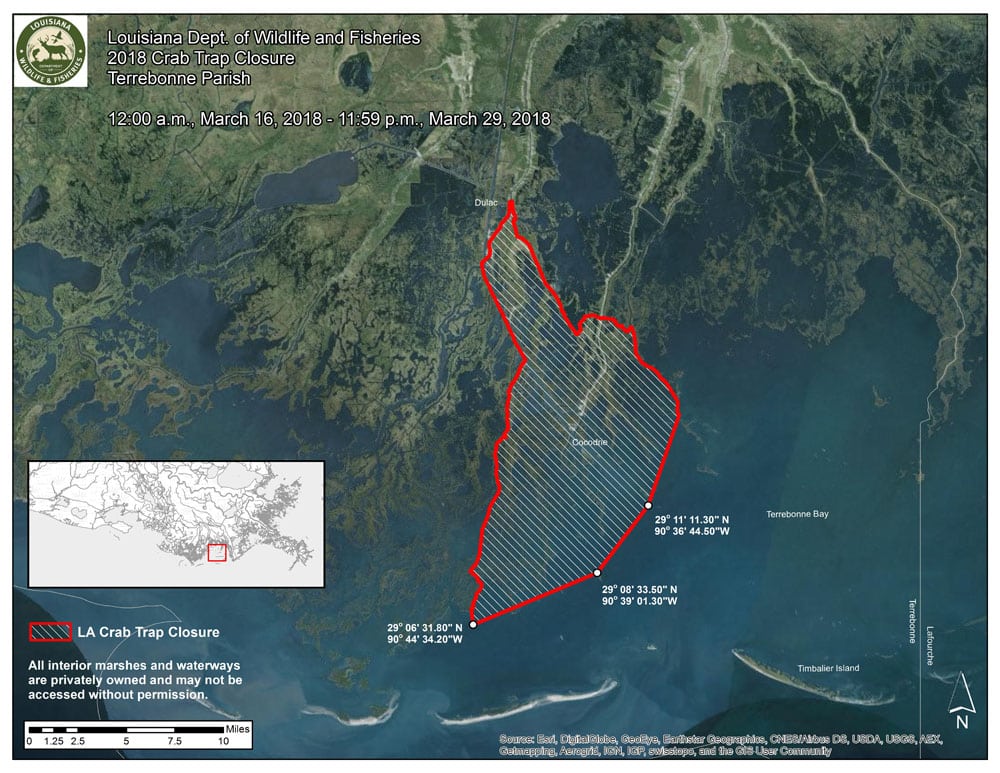
Click to enlarge
The use of crab traps shall be prohibited for a 14-day period from 12 a.m. March 16, 2018, through 11:59 p.m. March 29, 2018:
- From a point originating from the intersection of LA Highway 57 and Dulac Canal, then east along LA Highway 57 to its intersection with LA 56, then due east to the western shoreline of Bayou Little Caillou, then north along the western shoreline of Bayou Little Caillou to its intersection with Lapeyrouse Canal, then east along the northern shoreline of Lapeyrouse Canal to its intersection with Bayou Terrebonne, then south along the eastern shoreline of Bayou Terrebonne to its intersection with Seabreeze Pass, then southwest to channel marker number 17 of the Houma Navigation Canal (Lat. 29 ° 11′ 11.3″ N., Long. 90 ° 36′ 44.5″ W.), then southwest to the northern most point on Pass la Poule Island (Lat. 29 ° 08′ 33.5″ N., Long. 90 ° 39′ 01.3″ W.), then west to Bayou Sale channel marker (Lat. 29 ° 06′ 31.8″ N., Long. 90 ° 44′ 34.2″ W.), then north to the western shoreline of Bayou Sale, then north along the western shoreline of Bayou Sale to its intersection with Four Point Bayou, then north along the western shoreline of Four Point Bayou to its intersection with the Houma Navigation Canal, then north along the western shoreline of the Houma Navigation Canal to its intersection with Bayou Grand Caillou, then north along the western shoreline of Bayou Grand Caillou to its intersection with Dulac Canal, then east along the northern shoreline of Dulac Canal and terminating at its intersection with LA Highway 57
Vermilion-Teche Basin Crab Trap Removal
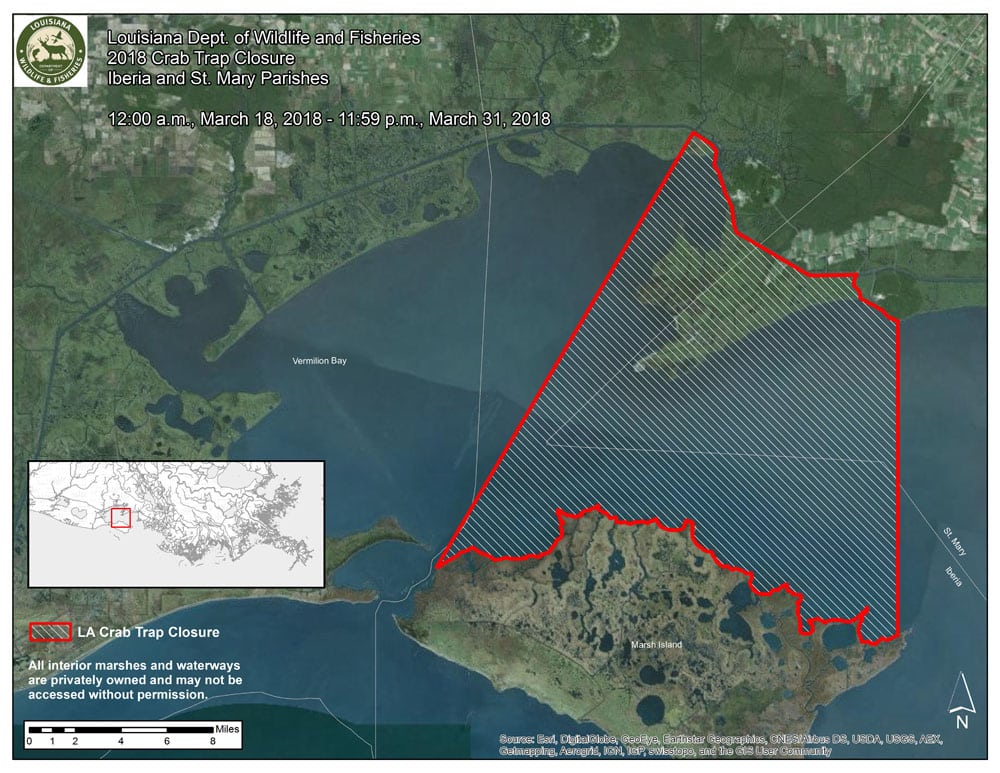
Click to enlarge
The use of crab traps shall be prohibited for a 14-day period beginning at 12 a.m. on March 18, 2018, and end on March 31, 2018, at 11:59 p.m.:
- From a point originating from the intersection of the Gulf Intracoastal Waterway and the Acadiana Navigational Channel, then southwest along the Acadiana Navigational Channel red buoy line to the red navigational marker number 12 on the Marsh Island shoreline near Southwest Pass, then east along the shoreline of Marsh Island to Longitude 91 ° 43’ 00” W, then north along Longitude 91 ° 43’ 00” W to the shoreline of West Cote Blanche Bay, then west along the northern shoreline of West Cote Blanche Bay to its intersection with the Ivanhoe Canal, then north along the eastern shoreline of the Ivanhoe Canal to its intersection with the Gulf Intracoastal Waterway, then west along the northern shoreline of the Gulf Intracoastal Waterway and terminating at the Acadiana Navigational Channel
For maps of 2018 closure areas, visit the LDWF Derelict Crab Trap webpage at: http://www.wlf.louisiana.gov/fishing/derelict-crab-trap-removal.
All crab traps remaining in the closed area during the specified period will be considered abandoned.
In the weeks leading up to the closure, LDWF will mail notices to all licensed recreational and commercial crab trap license holders and crab buyers within affected parishes as well as non-resident licensed crab fi.shermen who fish Louisiana waters and reside in Texas.
These proposed trap removal regulations do not provide authorization for access to private property. Authorization to access private property can only be provided by individual landowners.
Crab traps may be removed only between one half-hour before sunrise to one half-hour after sunset. Only LDWF or those designated by LDWF will be authorized to remove derelict crab traps in the closure areas. Abandoned traps must be brought to LDWF designated disposal sites and may not be taken from the closed area.
Interested persons may submit written comments relative to the proposed rule to Mr. Peyton Cagle, Marine Fisheries Biologist DCL-B, Marine Fisheries Section, 1212 N. Lakeshore Dr., Lake Charles, LA 70601, or via e-mail to: [email protected] prior to November 30, 2017.
The Louisiana Department of Wildlife and Fisheries is charged with managing and protecting Louisiana’s abundant natural resources. For more information, visit us at www.wlf.la.gov. To receive email alerts, signup at http://www.wlf.la.gov/signup.